Aeronautical Charts
Aeronautical charts provide basic air navigation data. However, they also contain a great deal of data on ground features, landmarks, elevations, and information that can be used for other purposes.
Most aeronautical charts in the Map Collection are located either under a Library of Congress call number, or under the U.S. Government, Superintendent of Documents (SuDocs) numbering system. The charts may be located using the Libraries' Catalog,and then retrieving the desired chart from the map drawer. (The map below shows the location of charts in the Map Room.)
Search Tip: When searching the Libraries' Catalog, you may find listings using the following search tip: Enter a subject search, beginning with Aeronautical charts-- followed by the country that you wish to locate. The following is an example:
s = aeronautical charts--ontario
This will locate all aeronautical charts that include Ontario.
Sample aeronautical charts
Aeronautical chart of the San Francisco Bay area [Scale 1:250,000]. VFR terminal area chart. San Francisco. Portion of a chart produced by the National Oceanic and Atmospheric Administration (NOAA) (318 KB GIF image)
Call Number: US C 55.416/ 11: SA 5 F.

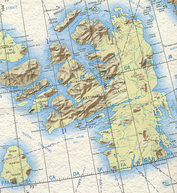
Aeronautical chart of Bathurst Island (Tuktusiuqvialuk) [Scale 1:1,000,000]. Operational navigation chart, ONC. B-7, District of Franklin, Northwest Territories, Canada. Portion of a chart produced by the Aerospace Center, U.S. Air Force. (421 KB GIF image) Note: This chart shows magnetic North in 1965.
Call Number: US D 5.324: ONC B-7/ 970.
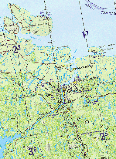
Aeronautical chart of the Murmansk Region, Russia. Operational navigation chart, ONC. C-2, Finland, Norway, Sweden, U.S.S.R. Portion of a chart prepared and published by the Defense Mapping Agency. (179 KB GIF image).
Call Number: US D 5.324: ONC C-2/ 976.